Tanoa, alternately the Tanoa Province, is a playable terrain in ArmA 3. It was added with the release of the Apex DLC.
Overview[]

| « | Walk, swim, drive, fly, and sail your way across 100 km² of South Pacific island terrain. Home to lush tropical vegetation, unique landmarks, a rich history, and imposing man-made feats of modern engineering, this 100 km² South Pacific archipelago is built to bolster authentic combat on a massive scale. Tanoa’s varied locations, such as the rainforests, volcano, shanty towns, sugar cane factory, and industrial port, cater to all scenario types. Whether it’s to conduct an all-out assault, a small-scale covert op, jungle warfare, or anything else suited to a South Pacific setting – Tanoa is the destination of choice. Your next adventure awaits. Official ArmA 3 website
|
» |
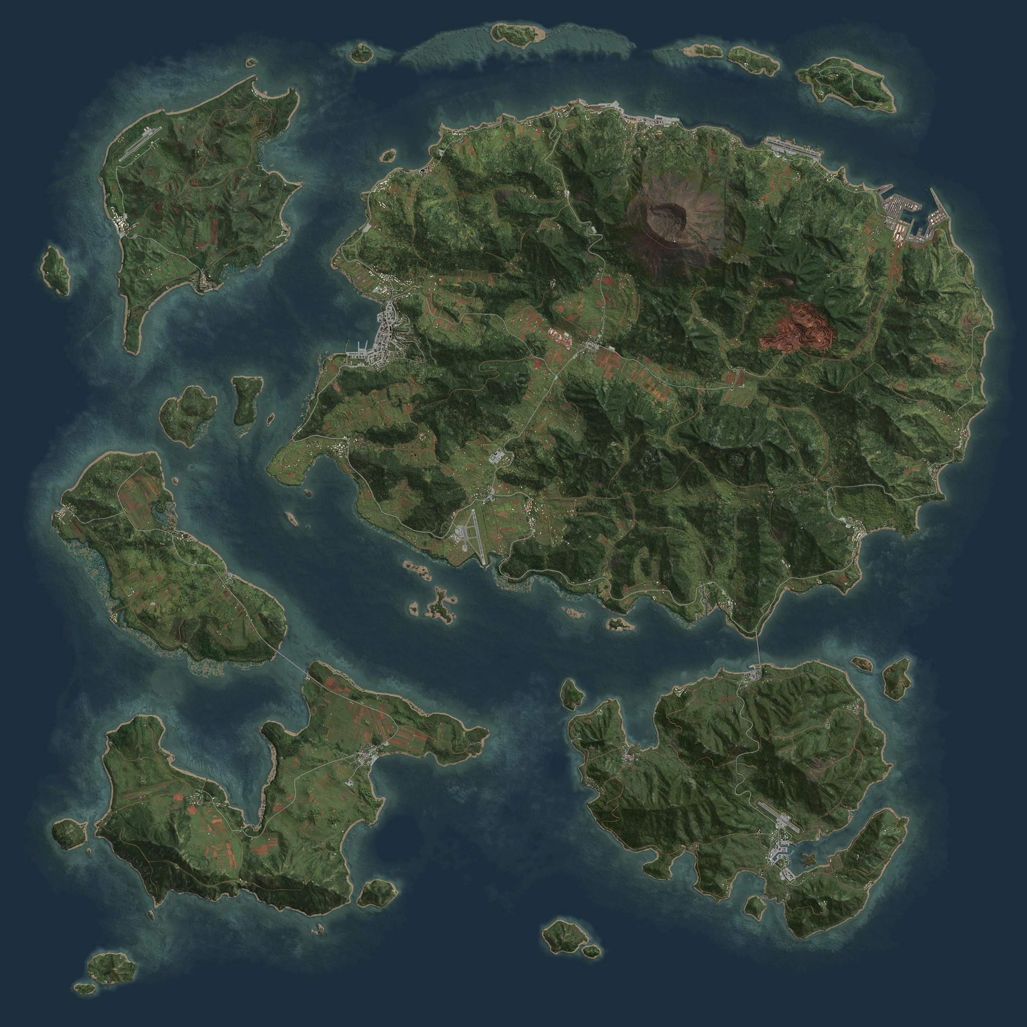
One of the four main archipelagoes in the Horizon Islands, the Tanoa Province comprises of five landmasses which together form the country's Northern Division:
- Balavu: The northernmost island in the south-west. Seven towns are scattered throughout the island; the largest (Balavu) being named after the island itself. A bridge and ferry route connects it to the neighbouring landmass of Katkoula.
- Katkoula: The southernmost landmass in the south-west. It consists of six towns, an airfield, two long range transmitter antennas and a small harbour for local ferries and domestic shipping. Its largest settlement is the town of Katkoula.
- Moddergat: South-eastern island. It has twelve towns and villages with the largest settlement being the town of Lijnhaven. Moddergat's populace are bilingual and can speak fluently in both French and Dutch.[1]
- Tanoa: North-eastern landmass. The largest of the five islands in the archipelago, the provincial capital of Georgetown is located here. Heavily industrialised, a railway network - mostly covering the west side - spans across the entire island and helps to deliver raw materials and harvested resources to the province's largest harbour: the Blue Pearl Industrial Port.
- Tuvanaka: North-western island. It is mostly devoid of civilian settlements and only consists of two towns, Tuvanaka and Belfort. In recent years following the government's political shift towards the East, almost three quarters of the island has been reserved for exclusive use by CSAT peacekeepers and is strictly off-limits to unauthorised personnel.
Etymology[]
The name of the archipelago comes from the Fijian word "tanoa" which translates to "bowl" in English. Its namesake stems from the main island itself resembling the shape of a large bowl.[2]
Geography[]
Combined, the five main islands and smaller landmasses cover a total of 100 square kilometres.[3]
Each island throughout Tanoa is typified by its abundance of lush tropical flora. The exterior of each island consists of mangrove swamps and sandy beaches but quickly transitions into dense, sprawling jungles covering a mountainous interior.
The highest point in the archipelago is located on Tanoa island at Mont Tanoa. A now-extinct volcano, its peak rises to 443 metres above sea level.
Settlements[]
With the sole exception of Tuvanaka which can only be accessed via ferries, the islands are all connected by bridges and can be traversed by car.
| Settlements on Tanoa | |
|---|---|
| Balavu Island | Balavu • Leqa • Laikoro • Muaceba • Namuvaka • Rautake • Tavu |
| Katkoula Island | Bala Airstrip • Cerebu • Katkoula • Koumac • Lailai • Savaka • Yanukka |
| Moddergat Island | Blerick • Bua Bua • Doodstil • Harcourt • La Foa • Lijnhaven • Lösi • Moddergat • Port-Boisé • Saioko • Rereki • Taga • Tobakoro |
| Ravi-ta Island | Ipota |
| Sosovu Island | Sosovu |
| Tanoa Island | Ba • Blue Pearl Industrial Port • Buawa • Galili • Georgetown • Imone • Kotomo • La Rochelle • Lakatoro • Lami • Lifou • Lobaka • Luganville • Momea • Nandai • Nasua • Nicolet • Oua-Oué • Ovau • Ouméré • Pénélo • Petit Nicolet • Red Spring Surface Mine • Saint-Julien • Regina • Tanouka • Saint-Paul • Savu • Vagalala • Vatukoulo |
| Tuvanaka Island | Belfort • Nani • Tuvanaka |
| Military installations | Aéroport de Tanoa • Comms Alpha • Comms Bravo • Comms Whiskey • La Rochelle Aerodrome • Saint-George Airstrip • Tuvanaka Airbase |
Points of interest[]
Blue Pearl Industrial Port[]
- Main article: Blue Pearl Industrial Port
The conduit through which almost all of the province's imports and exports flow[4], the Blue Pearl Industrial Port is operated by the Daltgreen Mining & Exploration Ltd. company.[5] It is one of the country's busiest shipyards and comprises of four sectors:
- Freight Forwarding (FF): The northern sector serves as the storage area where all containers are stockpiled. The primary crane way loads/unloads containers from ships with ten smaller crane ways lining the interior, separated into six lanes on the western side and four shorter ones on the eastern side.[6]
- Port Administration (PA): Blue Pearl's port authority structure is located to the west. The main building is situated right next to the entrance on the western side.[7]
- Power Station (PS): The main/backup power generators supplying electricity to Blue Pearl are built on-site. They are located on the port's eastern side where the dry docks are situated.[8]
- Transit Depot (TD): The southern side of the port forms the transit depot. It is used by tipper trucks to offload raw materials which are then processed and transferred via conveyor belts directly to ships.[9]
Due to its constant traffic, the sprawling dockyards are carefully monitored by government forces and is well-protected against potential looters and insurgent attacks.[10][11]
Mont Tanoa[]
- Main article: Comms Alpha
Mont Tanoa was once an active volcano. At its peak, sightseers are provided with a spectacular view of the entire province. However, in recent years, parts of the peak have been partially converted into a military installation. Designated as Comms Alpha, it is operated by CSAT peacekeepers and comprises of a radar dome and surface-to-air missile battery.[12][13]
Red Spring Mine[]
An open-cast mine located on Tanoa Island, this mining complex is vital to the province's economy and accounts for much of the resource exports. Due to its significance, it is extensively guarded by the local authorities and CSAT counterinsurgency operatives.[14] A dirt road running from the south, originating from the town of Vagalala, can be used to reach the mine on foot.
Terrain-specific texts[]
|
Gallery[]
") ") ") ") ") ") ") ") ") ") ") ") ") ") ") |
Video[]
")
Trivia[]
- Tanoa's landscape (at least for the main island) is largely inspired by the Oceania country of Fiji in the South Pacific. Some parts of the in-game city of Georgetown for example, are even based directly on real landmarks in Fiji's capital of Suva.[15]
- Whilst it isn't the first official tropical island terrain in the series (a position occupied by Sahrani in ArmA: Armed Assault), it is the first of its kind to feature thick rainforest jungles and shallow mangrove environments.[16]
- In the years prior to the release of ARMA Reforger, Tanoa was selected to be used as a testbed for the development of the Enfusion engine.[17]
- According to an interview with Pavel Šafář, the project lead of the Enfusion engine, the test was conducted on a Sony PlayStation 4 console. It was intended to measure how well the engine could handle it due to the amount and density of objects on the terrain.[17]
References[]
|
External links[]
See also[]
| Playable terrains in ArmA 3 | |
|---|---|
| Official Terrains | Altis (Amsterdam) • Livonia • Malden • Stratis • Tanoa • Virtual Reality |
| Third Party Terrains | Cam Lao Nam • Gabreta • Khe Sanh • Normandy • Sefrou-Ramal • "The Bra" • Weferlingen |
| Official DLC: Apex DLC | Contact DLC Creator DLC: CSLA Iron Curtain | Global Mobilization - Cold War Germany | S.O.G. Prairie Fire | Spearhead 1944 | Western Sahara | |